

Flying Training
Lesson 68: Class D Procedures and Special VFR
Saturday 4 Dec 2010 at 8.00am with Dave Cooper in Warrior VH-JAZ
Weather: scattered cloud 1500 feet, overcast 9000 feet.
Rain, rain rain: that's been the story of this summer. When I woke this morning to find it had rained steadily all night I assumed there would be no flying. The previous night's TAF certainly indicated this:
 TAF YSCN 031046Z 0312/0324 VRB03KT 9999 LIGHT SHOWERS OF RAIN FEW010
       SCT020 BKN030 TEMPO 0312/0324 4000 SHOWERS OF RAIN BKN008 RMK T 19
       18 18 19 Q 1015 1014 1013 1014
ie a few clouds at 1000 feet, scattered clouds (3-4 oktas) at 2000 feet and broken cloud at 3000 feet, with periods of rain during which the visibility would be 4000m with broken cloud at 800 feet. Not encouraging.
When I called Curtis, though (at 6.30am), Jim said it was fine for flying, so I had a rapid shower, skipped breakfast (not normally a good idea) and headed on down to Camden. On the way I checked the AWIS and it said overcast at 1000 feet, but as I approached the airfield and checked again this had changed to scattered cloud at 3000 feet.
To cut a long story short, Dave indicated that this was a good opportunity to experience some unuusal conditions, with non-standard procedures, and so it turned out. The plan was to make approaches from The Oaks, Mayfield and Bringelly (in whatever order I chose), and finish up with some circuits.
Dave suggested that with full tanks (as was the case) it was a good idea to follow a standard procedure: taxi on the right tank, to confirm fuel is feeding from it, then switch to the left for run-up checks and take-off. The radio in VH-HAZ was different from PBS, ie there was only one, so I tuned in 125.1 for the ATIS, with backup frequency 121.9 (Camden Ground). After making the taxi call I tuned the backup frequency to 120.1 and off we went.
I'd already decided on Mayfield first, then The Oaks and finally Bringelly, so after the run-up checks (and setting the transponder to 3000) we taxied to the holding point and requested a crosswind departure to the training area. Takeoff performance was pretty good with the cold air, and Dave commented that I was more relaxed than last week. (I had told myself to relax as I started the climb - it seems to be not uncommon for newbie pilots to tire themselves out by pushing on both rudder pedals, and I still sometimes catch myself doing this).
As we levelled out we could take in the scene. There was cloud all around us: overcast above, scattered cloud at our level and below us. Obviously a day to keep a good lookout, a good radio watch and your wits about you.
The distinctive gorge and bend in the river at Mayfield was covered in cloud, but at 2000 feet we were above it and could identify it by the surrounding features (racetrack, transmission lines). At this point I couldn't find the radio cheat sheet so Dave took over and orbited once while I looked for it. No go, but the content hasn't changed from the GAAP procedures, so it wasn't a problem. We were told to join base for 06 and report at 2 miles, and there were given number 3 behind a Skipper on late downwind. I couldn't see this aircraft so I slowed right down and Dave called the tower again to advise that we still hadn't sighted it. By default the tower will assume that you quickly identify the traffic, so this is a useful call to make. With their help we located the aircraft travelling left to right below us so were able to descend to circuit height behind it.
I concentrated on a good base leg and a stable approach, and it was a nice landing. Dave retracted the flaps and I accelerated down the runway again, took off and turned crosswind for The Oaks.
In the direction of The Oaks (which I identified by extrapolating from runway 24), the cloud was thicker. Although I'd climbed to 3000 feet to clear the RAA airfield there, it became obvious that we were going to be above the cloud, or actually in it. Dave used this as an exercise in requesting Special VFR Clearance by asking me to descend below the cloud. The Oaks is at an elevation of 800 feet, and the cloud was at 1500 feet, so to remain above 500ft AGL I had only 200 feet to play with. Dave pointed out that in non-VMC conditions the 500 foot limit does not apply - it's much more important to stay out of the cloud.
So carby heat on, throttle back and down we went. I hadn't seen The Oaks so close since I drove through it many years ago on the way to the viewpoint at Oakdale. It was now a matter of staying clear of obstructions while identifying Camden. Dave pointed out that the NDB would help here, and so it did.
To request Special VFR you just have to be in non-VMC conditions, and specify a reason. So it was:
"Camden Tower, Juliet Alpha Zulu, Warrior, The Oaks, one thousand five hundred feet, with Bravo [OK, I said Alpha], request Special VFR due to cloud.
The tower told me to join upwind, maintain 1500 feet and report at 3 miles. We were cleared for a visual approach as we were over the runway [It's a few days later now, and I'm trying to recall whether other aircraft were making 800 foot circuits at this point due to visibility] so we descended to circuit height and joined the downwind leg.
My landing wasn't quite as seamless this time (a slight ballon due to a heavy touch on the yoke in the flare) but convincing"Watch the balloon," Dave said) but with plenty of runway ahead I made a touch and go and then we were off again, to Bringelly this time.
We passed over Oran Park (display homes are starting to appear where the V-8s were racing last year) and then followed the Northern Road to Bringelly. As I was circling back to report inbound, the tower came on to ask all aircraft in the control zone whether they were happy to switch to right circuits on 06 to allow an aircraft to make an IFR approach (no gliding activity today!). As I was listening to the conversation I made another orbit to keep clear of the zone, and Dave was pleased with this example of airmanship. It was just as well, as it happened, because when I made my call I was told to stay outside the control zone - presumably because of the aforementioned IFR traffic. Dave was a little disappointed as he was keen to use this opportunity to have me experience an unusual approach to 06
To mark time till the IFR traffic was clear I flew north for a couple of minutes, keeping the Northern Road visible on the left, then turned and came back. Dave indicated it was a good idea not to stray too far in case cloud obscured the landmarks we needed.
When I made my inbound call the Tower asked if I could maintain 1800 feet (ie would I be clear of cloud at this height), and I confirmed I could. I was then told to track straight for Camden, maintain 1800 and report at the control zone boundary.
I reported abeam Oran Park, but when I reported downwind the Tower said they couldn't see us. Dave reported our position and they spotted us. By agreement with Dave I made one touch and go, a normal circuit and a full stop, for a total of four landings in the session.
As we cleared the runway the tower cleared us to taxi to parking, making it unnecessary to make a taxiing call (but I still had to switch to Camden Ground on 121.9). The grass was full so I parked outside the hangar. 1.4 hours and no time to relax and enjoy the view!
After the flight Dave commented that he was happy with my handling, and said I was more relaxed than last week. He did say that it was very important to have the appropriate maps with me in the cockpit at all times, and not in the flight bag! We agreed that there was not much sense doing any more circuits at Camden - much better to do them at unfamiliar airports.
Lessons Learned
- On a go-around, dump flap on the runway before powering up (in a Warrior; not in a Citabria!).
- Bring relevant maps (eg VTC) on every flight.
Photos
On the drive down I saw no fewer than five hot air balloons. The wind was flat calm, so perfect for balloon flights, though the overcast conditions made for less than spectacular pictures.
After the flight I wandered up the rows of parked aircraft, some gleaming, others looking little-used. Many are refugees from Hoxton Park (closed) and Bankstown (becoming expensive).
|
VH-JAZ at Parafield |
 JAZ panel (left) |
 JAZ panel (right) |
 Avionics panel |
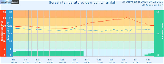
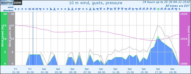
Weather
Checklist for next flight
- Book a half day and arrive 1 hour before departure to allow time for planning.
- Bring ERSA, maps, track already plotted: CN-Katoomba-Bathurst-Orange-Oberon-CN.
- Frequencies: for every landing point + alternates + Airservices (green frequencies only).
- Fuel calculations.